
"Wow! I've been to this place many times but never found it as beautiful as you've portrayed it," gushed a friend on Instagram (a popular photo sharing site, for the uninitiated) as I uploaded a panoramic view from atop the Lohagad fort, located about 92 km from Mumbai. Much as I would like to take credit for the beauty I captured, I can't, for most of the forts around Mumbai have a magical makeover during monsoons. Through most of the year the forts and the surrounding areas remain drab and brown, but in the three months of monsoon, they erupt in a burst of greenery, shrouded by mist and clouds, radiating an ethereal quality. And there's no better way to experience it than footing it out, even if it means aching joints the next day.
So that's how a bunch of us, 15 to be precise, decided to do a monsoon trek last year. We organised it through one of the many trekking groups in Mumbai. It is convenient as they will work out all the nitty-gritty like vehicle, food, toilet, changing facilities, permissions and route mapping. Our itinerary involved driving to Bhaje where we would visit the first century Buddhist caves and trek from there to Lohagad and back.

We started from Dadar in a mini bus around 6 am one Sunday. Breakfast was arranged at a villager's home at Bhaje village at the foothills of the mountain where the caves are located. Our guide, Varad, cofounder of Offbeat India that specializes in weekend treks, river rafting and other adventure trips, had also made arrangements for a room where we can change clothes if we wished. That was one facility which was not appreciated till much later in the day when we returned after a grueling 10km hike that also involved climbing close to 1000 steps (350 to Bhaje caves and 550 at Lohagad fort). But at that point all of us were more fascinated by the outdoor toilet, which looked straight out of a picture postcard! Breakfast was a simple but tasty affair, freshly made poha and piping hot cutting chai. The hosts were lavish with second and third helpings and it was only the thought of the long climb ahead that made most of us stop after the third helping!
The climb to the caves was not a difficult one. The steps offered beautiful view of the valleys and mountains around and there were many vantage points for photography enthusiasts like us. There is a ticket counter at the top where you have to buy tickets before entering the cave complex.

A group 22 rock-cut caves dating back to 200 BC, located on an ancient major trade route that ran from the Arabian Sea to the Deccan region, constitute Bhaje caves. They are an architectural marvel.
The most impressive monument is a large shrine -- chaityagriha -- with an open, horseshoe-arched entrance. There are upper levels caves with flight of small stairs on both sides of this cave. A fascinating feature of chaityagriha is the wooden rafters that support the arched roof that have survived centuries.
Apart from some Buddha images and sculptures that feature elaborate headdress, garlands, and jewellery, there are several inscriptions in chaityagriha. A cistern inscription shows the name of a donor, Maharathi Kosikiputa Vihnudata from the second century CE (Common Era). A wooden beam records two more inscriptions datable to second century BCE, indicating that these caves have been there for at least 2200 years.
Another notable part of the monument is a group of 14 stupas, five inside and nine outside a cave. There are some large and small empty halls with platforms on this floor, probably used for meditations.

Many combine the visit to Bhaje caves with two other Buddhist caves in the vicinity -- Bedse and Karla. Our group had planned to trek to Lohagad fort from Bhaje caves and decided to skip the other two caves. Any nagging doubt we had as to whether the other two caves should have been included in the itinerary was put to rest when a group of youngsters who had gone up to the Bedse and Karla caves walked in and were seen exclaiming that this was the best of the lot.
If you want to trek to Lohagad from Bhaje caves, my suggestion is to skip the other two. However, if you are keen to do all the three caves and Lohagad fort, instead of trekking to Lohagad village (an 8.5 km uphill trek) I suggest driving down to the base of the fort after visiting the caves. It's about 20km by road to Lohagad village from Bhaje village and the vehicle will take you to the bottom of the fort right where the steps begin.
The trek from Bhaje caves to Lohagad is an easy one compared to many others and offers some beautiful scenery. It's a popular route and throughout the path you would come across groups lazing around on the green grass or picnicking under trees. One can spot Lohagad fort kilometers away despite being camouflaged in clouds and greenery even during monsoon.

Simple food like poha, corn, vada paav etc and beverages like tea/coffee, soft drinks and bottled water are available at the base of the fort. Those who come trekking can recharge themselves before climbing the 500-odd steps to the top of the fort.
Situated on a side range of Sahyadri mountains, Lohagad divides the basins of Indrayani and Pavana rivers. The view of neighbouring Maval region and Pavana river and dam from the top of the fort is stunning. Once a formidable battle-station of Shivaji, Lohagad fort (also called the iron fort), commands a stunning view of the surrounding hills and hamlets.
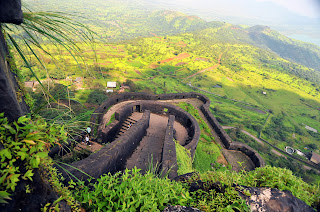
The fort, located at an elevation of 3450 feet, has a long history. It was occupied by many dynasties: Satavahanas, Chalukyas, Rashtrakutas, Yadavas, Bahamanis, Nizamshahis, Mughals. Shivaji captured Lohagad fort in 1648 AD but by the Treaty of Purandar he had to surrender it to the Mughals in 1665 AD. It was recaptured by Shivaji in 1670 AD and was used for keeping the treasury. In the Peshwa period, Nana Fadanis (1742-1800 AD) built several structures in the fort including a big tank and a step-well. The twin forts of Lohagad and Visapur were taken over by the British in 1818 AD.

The four large gates of Lohagad fort -- Ganesh Darwaja, Narayan Darwaja, Hanuman Darwaja and Maha Darwaja -- are very intricately arranged and are still more or less intact. The fort houses many old constructions and much of its fortification is very intact. The entrances and the ramparts are as they were 200 years ago and there are inscriptions on rectangular stones here and there.
Close to Lohagad, on its eastern side, is Visapur fort, considered its twin fort. Located at an elevation of 3500 feet, Visapur Fort is larger and also higher than Lohagad fort. Now in ruins, its history is closely linked with that of Lohagad fort. Making use of its higher position, the British troops in 1818 AD set up their canons on Visapur and bombarded Lohagad, forcing the Marathas to leave the fort.

By the time we climbed down, no one wanted to walk back another 8.5 km to Bhaje village. After confabulations at one of the small tea stalls that dot the base of the fort it was decided that we will take one of the cattle trucks. That it didn't have any seats and the 15 of us would be crammed into the back of a cattle truck standing or sitting on the floor was of little consequence at that time. No one wanted to walk. Period. The bumpy ride back was another adventure. Back in Bhaje village, where our hosts had prepared lunch, the famished and tired group of 15 had the tastiest food ever. As in the case of breakfast, hospitality was overflowing, and second, third and even fourth helpings were happily served.
The lunch we planned at 4pm had got advanced by two hours thanks to all of us wanting to put our photography skills to full use. But then no trip is fun if it is inflexible and timetable bound without giving you a chance to experience the sights and sounds and savour the little moments. That was aplenty in our itinerary.

Trekking in monsoon is a double-edged sword. Clearly, the view monsoon offers is unmatched in any other season. The entire path is covered with green grass and flowers and waterfalls surprise you at almost every turn. The mountains and the top of the fort covered with mist and clouds offer that dreamlike landscapes but the trek and the climb also become a slushy and slippery affair. Yet the scenery is worth every slippery step as the sheer beauty of the place as the rain drizzles and clouds roll over the mountaintops can turn even the most pragmatic person a hopeless romantic, albeit temporarily.


No comments:
Post a Comment